GEOTECHNICAL ENGINEERING
LITTLE ROCK
HomeInvestigationSPT (Standard Penetration Test)

Standard Penetration Test (SPT) in Little Rock: Get the Right Soil Data

Technical studies that support your project.

LEARN MORE

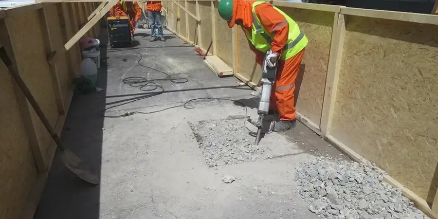
The CME-75 rig rumbles to life on a site near the Arkansas River, its 140-pound hammer lifting and dropping in a steady rhythm. That's the sound of an SPT in progress in Little Rock. Our crew runs the split-spoon sampler into the ground, counting every blow across three 6-inch increments. The N-value we record tells us exactly how the soil will behave under load. Little Rock's geology shifts fast—you can hit stiff clay in Hillcrest and loose alluvium a mile east near the river bottoms. The Standard Penetration Test gives us hard numbers, not guesses. For deeper bedrock confirmation in the western heights, we often pair the SPT with rotary drilling to capture continuous core through the weathered shale transition zone.

Arkansas River floodplain soils can lose 60% of their bearing capacity when saturated—SPT blow counts drop accordingly, and your foundation depth has to follow.

Our service areas

Process and scope

Soil conditions in Little Rock differ dramatically from one neighborhood to the next. Over in Chenal Valley, the weathered shale lies shallow, and SPT refusal often kicks in before 30 feet. Down in the Riverdale area, floodplain deposits of sand and silt can run 60 feet deep with N-values in the single digits. That contrast forces us to adjust the hammer energy and sampler type on the fly. We log recovery, moisture, and any sign of gravel lenses that could skew the blow count. The ASTM D1586 standard governs every step—from the 30-inch drop to the 2-inch OD sampler. In our experience, the raw N-value alone means little without local context. We apply overburden corrections and energy ratio adjustments based on Arkansas Geological Survey data. The result is a corrected N60 profile that structural engineers can use directly for bearing capacity and settlement analysis.
Standard Penetration Test (SPT) in Little Rock: Get the Right Soil Data
Technical reference — Little Rock

Local considerations

Little Rock's subtropical humidity and the Arkansas River combine to create subsurface conditions that punish assumptions. The biggest risk we see is SPT data from the dry season being used for a wet-season foundation design. Saturated alluvial silts near the river corridor lose shear strength fast when the water table rises after heavy spring rains. Blow counts that read 15 in August might drop to 6 or 7 in March. If the geotechnical report doesn't flag that seasonal swing, the structural engineer designs for soil that doesn't exist half the year. We log the groundwater level at the time of drilling and note the date, because a report without that context is incomplete. In the shale zones west of I-430, the opposite problem occurs: refusal at shallow depth can hide decomposed rock layers that swell when exposed to air and moisture during excavation.

Need a geotechnical assessment?

Reply within 24h.

Email: [email protected]

Regulatory framework

ASTM D1586: Standard Test Method for Standard Penetration Test (SPT) and Split-Barrel Sampling of Soils, ASTM D2487: Standard Practice for Classification of Soils for Engineering Purposes (Unified Soil Classification System), IBC 2021: Section 1803 foundation investigation requirements, ASCE 7-22: Minimum Design Loads for Buildings—geotechnical investigation provisions

Technical parameters

ParameterTypical value
Hammer typeSafety hammer, 140 lb
Drop height30 inches per ASTM D1586
SamplerSplit-spoon, 2-inch OD, 18-inch length
Recording intervalThree 6-inch increments per sample
Standard refusal50 blows in any 6-inch increment
Borehole diameter4 to 6 inches, rotary wash
Energy correctionN60 per Seed & Idriss methodology

Common questions

How much does an SPT boring cost in Little Rock?

A standard SPT boring typically runs between US$600 and US$740 per hole, depending on depth, access conditions, and whether we encounter refusal in shallow rock. Mobilization for the drill rig is included within the Little Rock metro area. If you need multiple borings or a full geotechnical report with foundation recommendations, we provide a package quote after reviewing the site location and your planned structure.

How deep do you drill for SPT in Little Rock?

Depth depends on the site location. In the Arkansas River floodplain—downtown and Riverdale—we often go 40 to 60 feet through alluvium before hitting bedrock. In west Little Rock near Chenal Valley, weathered Jackfork Sandstone can stop the sampler at 15 to 25 feet. IBC requires borings to extend through all unsuitable material and into competent bearing strata.

What is an N-value and why does it matter?

The N-value is the number of hammer blows required to drive the split-spoon sampler 12 inches into the soil, after an initial 6-inch seating drive. It correlates directly to soil density and strength. A blow count below 4 suggests very loose sand or soft clay—problematic for foundations. Above 30 indicates dense soil or weathered rock. We correct the raw N-value for overburden pressure and hammer energy to produce the N60, which is what your structural engineer uses for design.

How long does SPT testing take on site?

A single boring to 40 feet in typical Little Rock soils takes about half a day of field time. If we hit shallow refusal in the western shale zones, the boring finishes faster. Deeper holes in river alluvium or sites requiring multiple borings can extend to a full day or more. Lab classification of the recovered samples adds a few days before the final report is ready.

Location and service area

We serve projects in Little Rock and surrounding areas.

View larger map